From the National Forest Site:
When Grandview Lookout Tower was originally built in the 1930s, it was a particularly active period for lookout tower construction, and most of the tall steel towers still in use today date from that period. Steel towers, the "cabs" in which the lookout sits, and the associated residential cabins were built to standard architectural plans. Grandview Lookout Tower is typical of other towers built during that era. The tower is 80 feet tall, and the cab is 7 feet square. We actually started our Jeep ride just north of Tusayan, which is just south of the GCNP south entrance. It is a dirt/gravel road all the way, about 19 miles with a side loop on FS Road 301. The trip is mostly through the Kaibab National Forest land. Rolling hills and occasional large sections of granite outcroppings.
Along the road we came upon several "tanks" that I assume serve the livestock and wild stock during the arid months of the local climate. They basically are small man-made reservoirs that catch run-off from snow melt and summer thunderstorms and will hold water for many months. I would also assume that they woulkd also serve the Forest Service in providing water for helping put out local fires.
Typical road surface and landscape we encountered along FS road 302. As you can see, we had a gougeous day to be outdoors and away from the maddening crowds of the South Rim area of the GCNP. As Al & Kelly (The Bayfield Bunch) know, and I adopt this position as well, these little forays are nice getaways.
Along the way we took little walks to stretch out the legs. Here, we walked around the Grsandview Lookout tower, but only ventered up two levels of the tower. At 7500 feet elevation here, it doesn't take long for one's lungs to be over worked.
One of the stone outcroppings along the way.
Above, Joe and the Native American Ranger. To get the South Bass Trailhead, one must traverse a one way road (FS road 328) for about 30 miles. The ride begins either from the town of Tusayan or from a road in the Grand Canyon Village at the Maswik Lodge. Along the road, and after about 20 miles in the Kaibab NF, you come upon a gate that enters into the Havasupai Native American Reservation. The photo above (I aways ask before I take any photo of Native Americans) shows the Ranger holding the pad of permits that are issued to anyone who pays the $25 that grants them permission to cross their reservation. He was a very soft spoken person with a gentle aura about him.
The road eventually winds up at the South Rim and specifically at the South Bass Trailhead. The trail is one of the many trails that folks use to go down to the Colorado River, and from what I was told by a hiker we met on the way out, most hikers pack in for several days.
Forest Service road 328
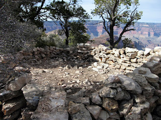
At the trailhead, there is an old cutout type cave just beneath the overlook that has been shored up with rock and mortat to form a shelter of sorts for I assume past hikers to the trail. This cave was about 8 feet deep and was about 4x6 feet across. Just above this was another old rock foundation that once was a shelter as well.
The rock shelter ruins sitting on the rim edge and just above the cave shelter.
Another view of the shelter ruins. Note the background west rim of the GC.
Typical road and flora of FS road 328 near the South Bass trailhead
View from the overlook of the north rim, about 20 miles west of the GC Village.
The parking lot with four other vehicles that apparantly carried hikers here for going on the South Bass Trail. No one was around and it was so quiet and peaceful here that we didn't want to leave. Just awesome.
Another view to the north rim.
Looking west towards Skywalk. We didn't go on Skywalk, which is owned and managed by the Havasupai Tribe.
On the way back from the trailhead, we tried to take a photo of Humphrey's Peak near Flagstaff, about 30 miles southeast. From wiki: The San Francisco Peaks are a volcanic mountain range located in north central Arizona, just north of Flagstaff. The highest summit in the range, Humphreys Peak, is the highest point in the state of Arizona at 12,633 feet (3,851 m) in elevation. The San Francisco Peaks are the remains of an eroded stratovolcano.[1] An aquifer within the caldera supplies much of Flagstaff's water while the mountain itself is located within the Coconino National Forest and is a popular site for outdoor recreation. The Arizona Snowbowl ski area is located on the western slopes of Humphreys Peak.
Well, I've rambled enough for one blog, so it's off we go. Today (4/5) we pack up from the Grand Canyon Trailer Village and head a little east to Winslow and the Four Corners area. This evening I'll do our Grand Canyon blog and include some neat photos as well. Our album on Picasa web has all the photos for this and many more albums from our current journeys. Till then, RVing Beach Bums, Joe & Nancy.


great shots of the GC!!..what an adventure!
ReplyDeleteWish I were with you, beautiful, beautiful!!!!Your sister Deb
ReplyDeleteLooks amazing and makes me even more excited to be on our way there in just over a week! Great photos!
ReplyDeleteI enjoyed your post today. I learned of it by the Bayfield bunch. It made me want to go to grca. Thanks.
ReplyDelete