Joe and Nancy

Joe and Nancy
Our Home on Wheels (Click on image above for our web albums.)

Wednesday, December 7, 2011

Great Smoky Mountains NP #5

I ended my last blog by saying it was #3, when in fact it was #4, as this is #5.  It was a day trip over the Balsam Ridge, via the Blue Ridge Parkway.  From the NP website:  The Balsam Mountain area is an excellent high elevation escape offering spectacular mountain views and loads of summer wildflowers. To reach the Balsam Mountain area you must leave Great Smoky Mountains National Park briefly and drive the scenic Blue Ridge Parkway. The parkway begins midway between Oconaluftee Visitor Center and Cherokee, NC. Exit the parkway near milepost 458 at the turnoff to Balsam Mountain Campground. You will follow the mile-high Heintooga Ridge Road for eight miles to Balsam Mountain Campground (elevation 5,310').
 We didn't want to leave this spot.
 Way down there in the valley is the Cherokee Harah's Casino.  Our RV is parked about one mile from there.  It was called Happy Holiday RV Village.  Very nice place, fairly large spaces and real friendly folks. I recomend it next time your in that neck of the woods.
 Balsam Ridge Campground right on top of the mountain, 5000 feet up.
 So much to take in and so little time to do it.  I need to slow down some.
 My trailblazer out front, protecting from the snakes & bears and whales.  Well, we didn't see any, so she did good!
 To take a road less traveled, drive to Balsam Mountain via the Heintooga Ridge Road that starts at the Blue Ridge Parkway at Milepost 458.2, just 11 miles from the south end of the Parkway. Most of these later pics were taken from the Heintooga Road which descends down from the Balsam Ridge into Cherokee, some 26 miles on gravel and through large hardwood and Balsam forests.
 We ran into this big boy and three of his cows at the Masonic Shrine on Balsam Ridge.
 Wow, what panorama. It was jusr so inspiring, yet peaceful.. This retired life is the cat's meow.
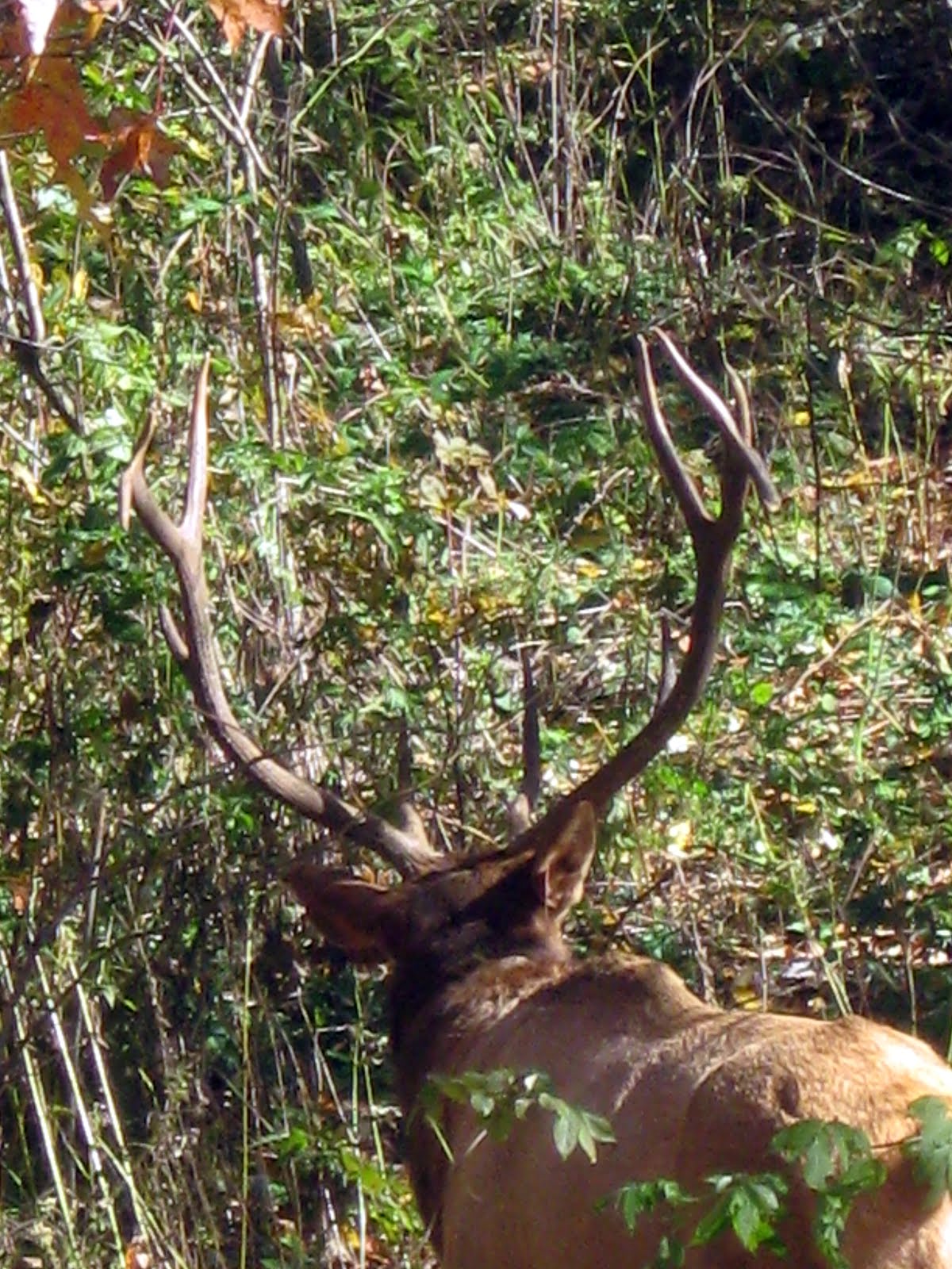
 What a rack on this old boy.
 There were about ten of these humongous picnic tables at the NPS park at the start of the Heintooga Road.
Well, that's about it for this daytrip and blog.  So, till next time, Joe & Nancy, the RVing Beach Bums.


Great Smoky Mountains NP #4

 Big Cataloochee:  Much like Cades Cove, this valley supported a relatively large population and actually was nearly self sustaining for many decades.  From Wiki:  Cataloochee is a valley in the Great Smoky Mountains of North Carolina, located in the Southeastern United States. Now a recreational and historic area within the Great Smoky Mountains National Park, Cataloochee was once home to a substantial Appalachian community and Cherokee hunting ground.
Elk were reintroduced into the park in February 2001 when 25 elk from the Land Between the Lakes National Recreation Area were released in Cataloochee. Most of the original $1.1 million cost was funded by the Rocky Mountain Elk Foundation, which provided $700,000.[33] Elk once roamed the highlands of Southern Appalachia, but were eliminated by overhunting and loss of habitat. Elk herds are a common sight in Cataloochee in the Spring and Fall.

 I am actually standing in a creek bed near the old curch building looking back at the road that disects the Cataloochee Valley.
 We found out later that this old girl was sick and unable to eat the natural grasses and other mast falls available for some reason, and was susceptable to taking handouts from tourists, which is a big NO-NO.
They love apples.
 We saw hundreds of turkeys over our two week journeys in the Smokies.  Below is a Ruffled Grouse.
There are many such roads one can choose to cruies at a liesurely pace, and stop whenever to take it all in and breathe the fall scents of falling & decaying leaves.  Just so nice here in the mountain, so primitive still.
 We had just a lovely day touring around the Cataloochee Valley.  We took it all in.
So, this wraps up GSMNP #3.  Until next time (and the Skyway photos too), RVing Beach Bums.


Great Smoky Mountains NP #3

 This cabin was in the Roaring Fork drive above Gatlinburg. Here is a clip from the NP website: The narrow, winding, Roaring Fork Motor Nature Trail invites you to slow down and enjoy the forest and historic buildings of the area. The 6-mile-long, one-way, loop road is a favorite side trip for many people who frequently visit the Smokies. It offers rushing mountain streams, glimpses of old-growth forest, and a number of well-preserved log cabins, grist mills, and other historic buildings.  You can see the rain again.  Ugh!
 All these pics are from our drive down the Roaring Fork Nature Drive.

 This was one of the more modern cabins (house?) in the Park (Nature Drive). It was near the end of the drive.
Above, part of Fontana Lake on the NC/TN border, just above Fontana Village.
 Have you ever heard of the Tail of the Dragon? It's on US129 in NC just above Fontana Lake.  Here is a clip from a website.  The road has 318 curves in 11 miles, is America's number one motorcycle and sports car road. The nearby CHEROHALA SKYWAY is quickly becoming number two with its remote 60 miles of scenic mountain highway. We went on that too.  I will share the pics from that drive in my next blog.  These two "bike riders" were professionals.  They went at unbelievable speeds passing us on our way to this spot.  I mean very fast.  They had these knee pads that were dragging in the curves making sparks as they turned & leaned left & right.  Quite a show, but very dangerous as there was lots of traffic on this beautiful Sunday afternoon.
 Yoe have to look carefully, but both these guys took off and left on ONE wheel, all the way around that curve about a quarter mile away.
 I hate to get power lines in my pics, but sometimes you just can't help it.
OK, that's about it for this blog, as I will now get on with my next one and it will include our pics from the Cherohala Skyway drive we took.  It was quite a contrast from the valley to high above in the clouds, literally.  So, till then, RVing Beach Bums.