Joe and Nancy

Joe and Nancy
Our Home on Wheels (Click on image above for our web albums.)

Thursday, March 31, 2011

Hoover Dam & Valley of Fire

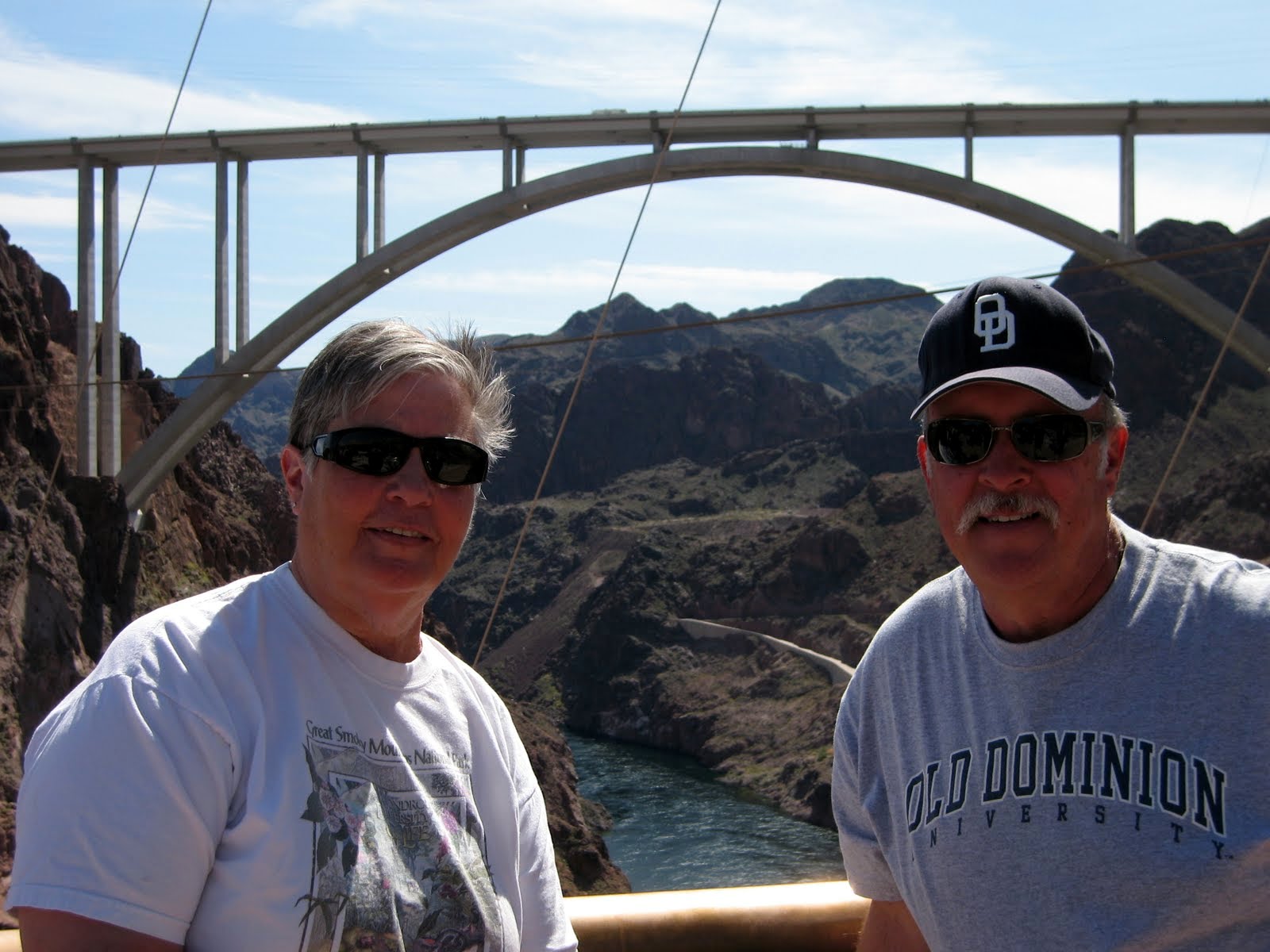
Nancy & Joe on the visitor's deck overlooking the dam to Nancy's right and the new highway 93 bridge over troubled waters (sorry, couldn't resist).  The waters are not troubled, really, just me.  :-))  We couldn't believe the amount of people here today as we thought it might have been a product of spring breaks, or the fact that it was Sunday.  But our tour guide said it's like this every day, and really is busier during the weekdays.  WOW!  The elevators were packed every time.
Way down there.  And I am not too fond of heights either.  I dared not venture too close to the edge, or I would get dizzy.  The video we saw on the construction of the dam during and post great depression days was just incredible, the feats and accomplishments of the work force.

The dam holding back the mighty Colorado River which forms the largest man made lake in North America, Lake Mead.  Lake Mead is down about 90 feet from it's normal levels as the drought has continued now for nearly ten years, according to our guide.  He also explained that they were expecting a huge runoff from the big winter snows and were expecting to regain about 30 feet of water by summer as a result.  WOW! 

One of the large river diversion intakes.

Deep inside the tunnels of the dam, just out from the intake overlook.

The turbine viewing room.  To the left and down are the turbines in the above photo.

Two of the four large water intakes that provide the force necessary to move the turbine impellers.

Valley of Fire State Park Visitor's Center

Just inside the Park a mile or so, a side road takes one to the cabins.  They were built by the CCC in 1935 for the workers and later weary travelers and visitors.

Miss Nancy at the visitor's entry point where one deposits their park entry fees.

The park was about 12 miles long on paved surfaces, mostly, with a few side roads of dirt/gravel.

From Wiki: 
Valley of Fire State Park is Nevada's oldest state park. It covers an area of 34,880 acres (14,120 ha) and was dedicated in 1935. It derives its name from red sandstone formations, formed from great shifting sand dunes during the age of dinosaurs. These features, which are the centerpiece of the park's attractions, often appear to be on fire when reflecting the sun's rays.

Several of the side road trails one can explore will reveal many petroglyphs from many centuries before by a native people who inhabited the area before.  There is much controversy as to just exactly the images mean or what was being expressed by the authors.

There were many opportunities for photos of the petroglyphs.

Enjoy the view!

The trail to the Mouse's Tank

The Mouse's Tank...we never understood why.  Guess Google knows!  :-)

Miss Nancy looking at a high rock face full of petroglyphs, and on the way to the Mouse's Tank.

Awesome is the only thing I can say.

One of the side roads leads to here.

Fire Canyon

Are we still on earth?

Lots of photo ops

One of the side roads.  This one lead us to Fire Canyon and Silica Dome.

Petrified putty?

Well, here we are near the end of another great day in Southern Nevada.  It's amazing what one can see around here, especially when there is something close by that seems to attract everyone to:  The Las Vegas Strip.  So, I guess it's time sign off for now as we head for Grand Canyon NP and expect to be there at Trailer Village at the South Rim for about week, 3/30 to 4/5  I still need to post a blog on my Sister's visit to Las Vegas last week.  I will do that this evening perhaps.  I will also need to post our day trip to Good Springs, NV, a ghost town.  I'll do that tomorrow.  Till then, Joe & Nancy


Wednesday, March 30, 2011

Red Rock Canyon, NV

From Wiki: 
Red Rock Canyon National Conservation Area in Nevada is an area managed by the Bureau of Land Management as part of its National Landscape Conservation System, and protected as a National Conservation Area. It is located about 15 miles (24 km) west of Las Vegas, and easily seen from the Las Vegas Strip. The area is visited by over 1 million visitors each year. 


The Park is actually a 17 mile loop through a beautiful canyon. 

We spent the entire day up here, as there was much to take in.  The unusual colors and formations was just mezmorizing.

There was lots of fool-hardy folks climbing all over these rocks.

Can you make out the folks hanging off the face of this "rock"?

These folks had set up a little base camp below another face and were preparing lines to traverse up from this camp.  They may be hard to see, but there there.

This is another shot of the folks who set up a little camp to go vertical.  I just pulled back the zoom a little so one could get a perspective as to what lay ahead of them, straight up.  Crazy!

What a contrast in color.

More colors to enjoy.

On the way out one can still look over the expanse of the desert meadow and shoot a nice pic of the colorful mountain.

We managed to do a little off roading up one of the canyons about half way through the park.  This photo was up about halfway, or about 800 feet up from the paved loop below.

On the California side of the Park, the mountains take a different hue.

Near the exit of the Park, we took a little hike to stretch our legs.

It was rather windy day, but a warm 65 kept us active and interested in everything around us.  There was also a lot of folks up here as it was Saturday, 3/26. 

This was taken just outside the loop.

We saw these little 3-wheelers up in the loop, and here they are on their way back to Las Vegas.

Neat little off road we took off the paved loop looking toward Las Vegas to the east.

Way off in the distance about 15 miles lies the Strip,and that is where we're headed.  We're looking to have some dinner at one of our favorite eateries, Sweet Tomatoes (Soup Plantation in some states).  Al of the Bayfield Bunch probably wouldn't approve, as they serve just salads and soups.  :-)) And lots of varieties.  And I am sad to report, that Al & Kelly are on their way back to Bayfield, ON.  They have ended their wintering over in the Great Southwest and hopefully will return next fall.  Al & Kelly, have a great & prosperous summer back home, stay healthy, welcome many visitors at the Lodge, and get back down here soon.  So, till the next blog, Joe & Nancy


Tuesday, March 29, 2011

Reds Spring Training & Golfing in Goodyear, AZ

The scoreboard from the back
This is the second year the Cincinnati Reds have been in Goodyear, AZ, having moved from Sarasota, Fl.  They share the 12 ball fields and this main field for their games with the Cleveland Indians.  There are 13 other major league teams in the Phoenix area and I believe the Reds have played each of them at least once this spring. 
This is the other side of the scoreboard.

Joe & Nancy sitting on the grass berm just behind the left field wall.

A view from the infield box seats.  Note the berm below the scoreboard, and we were playing the Cubs this day, and we "killed" the "Cubbies".

Homer Bailey (pitcher) warming up before the game.

Johnny Gomes stretching out.

The right field food pavillion where one can partake of the buffet and a bar.  We upgraded a couple times to this seating area, on Sundays right after Church.

Paul Janish, infielder stretching out his legs

Dusty Baker (Manager) siging autographs before the game.

Joey Votto, the National League MVP last year getting ready to hit a home run.

Jay Bruce getting his whacks in.

Well, guess I need to say goodbye to the Reds and Goodyear, AZ.  We hope to return next spring and will get the season tickets once again for each home game (16 games) at the Goodyear Park.  But before I close out this blog, I want to share a few photos of my golfing with my friend and former colleague at Northrop Grumman, Bill Cochran, who happened down to Goodyear for a week of golf and the Reds.  He too has plans for a return engagement next year.

Bill Cochran, my driver :-) each day we golfed at various courses.  This was Tres Rios Golf Course.

Alice, from Canada, a native of Czechoslovakia, played in our group at the Wigwam course.  She was a hoot and kept us in stitches the whole round.  She rewarded us with hugs when we made good shots.  :-)

Bill setting up for a short iron to the green.  Alice is encouraging him...

Our foursome at the Wigwam Course.  The taller man at the left is Richard (forgot last name) and he just happened to be in Goodyear watching his son-in-law in spring training.  Who is his son-in-law you might ask?  What a coincidence:  Bill Bray, a pitcherfor the Reds, and, Bill Bray is from Ocean Lakes High School in Virginia Beach, where we live.  WOW!  Alice sang "It's a Small World"...and it really is...

Bill, recieving some additional "encouragement" after our round.  He stated to me at the time, "What's your hurry Joe"?  Hmmmmm...

I just hit my ball in the swamp up by the green and Bill was explaing where it went in.  Thanks Bill!  This was the Falcon Course right next to Luke Air Force Base and we watched F16 Falcons take off all morning.

Early morning on the Falcon Course.

Well, I guess it's time to bid adeau to the Phoenix area for this year as we prepare to move on to Las Vegas to meet up with my Sister and her family.  More about that in my next blog.  We hope to return next year to the Reds and the wonderful weather Phoenix offers in March.  A little windy at times, but nonetheless, beats most any day in March back home.  Till the next blog, Joe & Nancy