

On the way to the Apache Trail (AZ highway 88), if entering from the south, one will pass by Superstition Mountains near Apache Junction, just east of Mesa. This photo was actually snapped from the The Lost Dutchman State Park, at the foot of the mountain.
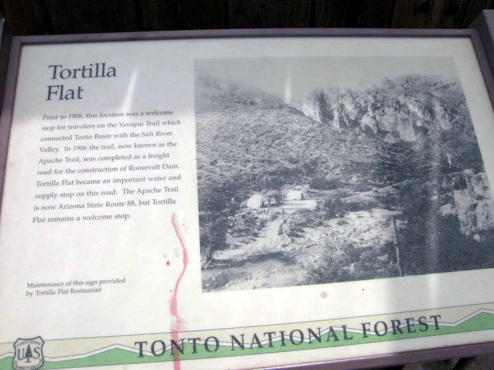
About 18 miles into the Trail is Tortilla Flat. It is a small community of about three houses and a restaurant, gift shop and gneral store with an ice cream shop inside. Yep, we had to have dip on a cone.

The town was really crowded this day, a Saturday around mid day, and of course sunny and warm. Lots of bikers and folks just wanting to get out of town for the day. The road to here was all asphalt, but that was abou tto change.

A couple park rangers assisting and advising folks on trails and answering questions.

From the front porch of the Saloon at Tortilla Flat.

Shortly after leaving Tortilla Flat the road turns dirt/gravel, and there was 21 miles left! Our destination would be Roosevelt Dam and the Tonto National Monument, at the end of the dirt road.

Typical view along The Apache Trail

Nancy said at one point that this stretch of the AT remindered her of a little Grand Canyon.

This is the Fish Creek Hill part of the Trail, very steep and narrow. Nice! We would be going down this next.

Fish Creek Hill area

Fish Creek Hill

At the bottom and the bridge goes over Fish Creek

The bridge from a different view

Mummy head, or Budda?

Canyon Lake

Typical view

Joe & Nancy, RVing Beach Bums

Many Saguaro along the Trail

Nancy caught me at the edge of a cliff above Fish Creek

From the Tonto National Monument (cliff dwelling ruins) overlooking Roosevelt Lake. The lake was about 7 miles away.

Ruins of the cliff dwellings at the Monument

Your's truly in the ruins. This part of the ruins is called the lower part, which is unique in that they can be interactive with the visitors. The upper dwellings, which did not visit due to time, can only be viewed from just outside the rooms. From Wiki:
Well-preserved cliff dwellings were occupied by the Salado culture during the 13th, 14th, and early 15th centuries. The people farmed in the Salt River Valley and supplemented their diet by hunting and gathering native wildlife and plants. The Salado were fine craftsmen, producing some of the most flamboyant polychrome pottery and intricately woven textiles to be found in the Southwest. Some of the artifacts excavated nearby are on display in the visitor center museum.
Another view from the ruins of the lake

The ruins

Miss Nancy in the ruins. The ranger here in the ruins was very informative about the dwellings, the Salado People who inhabited them, and there way of life and other dwellings around the area.

Our new addition to the RVing Beach Bums: Our Sahara Unlimited Jeep. We traded Miss CRV in on this.

Roosevelt Lake.
So, we left the Tonto NM and headed for Globe, AZ, and we discovered we were about 90 miles from our motor home. How did this happen? Guess we were having too much fun exploring! :-)) Better run for now. Next blog will be our run up the Castle Creek Resort Trail from Morristown to Pleasant Lake. Till then, Joe & Nancy
yeah for the jeep!!..now you are talking!!!..woohoo!!..welcome to the jeep club!!
ReplyDeleteTwo thumbs up on the Jeep:)) Now you can travel to Planets in far off Galazies where no one has gone before:)) It was one year ago right about now that we were staying at the Lost Dutchman there at the foot of Superstition Mountain. Gotta love that Apache Trail drive out past Tortilla Flats & beyond. Too bad that big Megopolis of Phoenix/Apache Junction has already spread itself right to the foot of Superstition Mountain.
ReplyDelete