Wednesday, February 29, 2012

Martha's Garden Medjool Dates Tour

We were here last year during our stay at the Army's Yuma Proving Ground RV Park (Desert Breeze).  We both like the dates and eat them like candy.  Too many however can get you making more trips to the potty than normal, so I try to hold my intake to less than 6 or 7.  But the date shakes are really good.  Yummy!  I try to hold my intake to less than 7 also for these.  Ha!
 This was our little tour wagon and the guide was actually the 42 year old son of the the owner/founder of the orchard.  Martha is actually his grand mother.  We never realized how much effort went into the pollenization, cultivation, and harvest of these dates, in this desert setting.  Each female tree (8000) must be hand-pollenated from the flower of the 80 male trees.  The guide went into excrutiating details of the entire operation of the family run and operated farm/ranch.
 Above, he is attempting to show us the female pod that is about to "bloom", at which time it will be ready to receive the male pollen.  Below is the female pods.  The bag he is holding will be placed around the entire pod after pollenating.  The bag protects the pod from birds, insects and rodents.  It also protects the dates when near-ripe from the sand/dust as they become very sticky.
 They also have rattlesnakes to contend with, but they keep the rodents (ground squirrels) in check somewhat.  But the rodents are their biggest challenge.  They use a decon-like killer to help in controlling their numbers as well.

 Above & below are pics of the Gila River flood plain and the fertile valley of many centuries of floods.  The river long ago was dammed and diverted with the Colorado River in order to establish a series of canals and irrigation capabilities for the huge produce growing, citrus, and many other hay/cotton crops that are grown throughout the year.
 The canal above is one of the many throughout the Yuma Valley.  The sol is so rich, it appears that anything could be grown here, and it does, according to our guide.
 Abovem he explains that the tree produces many leaves/branches that sell to the local artisans/crafts people to make all sorts of baskets, hats and other items for sale in the local tourist traps.
 Above is an example of how each mature tree produces many offshoots that wind up being cut, transplanted, and eventually put in the ground and makes another tree.  Each tree will produce 4-6 offshoots each year.
Above, he explains the harvest/sorting/grading/freezing/packing/shipping processes.  We just couldn't get over the amount of labor that goes into the entire cycle of how the dates get to the consumer.
 Above is the device that is used to "lift" the workers up to pollenate/bag/harvest the dates.
Above are some of the offshoots that were recently transplanted into pots in one of the nurseries.  Below is a tree (female) that has just been pollenated.  In a few days each pod will be wrapped in a bag.
We did wind up buying a large box of the Medjool dates.  We froze most of them and will enjoy them for many weeks to come.  Well, so ends our tour of Martha's Garden.  It was 90 minutes of education and quite relaxing to ride around in the warm sunny afternoon.  So, until next time, RVing Beach Bums, Joe & Nancy.


Saturday, February 25, 2012

Lake Kaweah To Mojave National Preserve

This was the view out our front window at Horse Creek Campground on Lake Kaweah.  The Campground is run by the Army Corps of Engineers and is situated at the upper end of the lake.  Normal lake level at this time of year is very near the high water mark across the valley in this photo.  We normally could not park in this spot as the road to get this spot would be impassable.  
 Above is the marina at the dam of the lake.  Below is looking up the lake towards Horse Creek.
The lake during normal rain/snow fall in the mountains to the west is nearly full by the end of February.  But obviously precipitation has been lacking this winter.  This will have an impact on the agriculture in the valley below stretching to Visalia, CA.  The farmers rely on the water from the lake to supply the many canals and irrigation ditches to water their crops and citrus for the summer.  That will be a real challenge this year, unless more rain/snow falls soon.
 Snapped this pic of a woodpecker just outside our MH window.  Not sure what kind it is however.  It seemed to think that there were bugs in the logs of the office building.  
 We took a side trip into town (Visalia) one morning and snapped a photo of a mural dedicated to the Viet Nam veterans.  There were several murals in town on different buildings dedicated to veterans of other conflicts & wars our men & women have been engaged in.  Nice touch by the City Fathers to allow such memorials.  Below was some sort of flower resembling a rose that was in the little plaza where this mural was located.
 Above & below are photos from our campsite in Mojave National Preserve.  The campground was called Hole In The Wall and was 20 miles off I-10 about 50 miles east of Barstow, CA.  The campground was remote and windy.  The location was right in the middle of a canyon, and for anyone who has camped between two mountains, understands the "canyon effect" wind currents.  We could hardly spend time outside the MH while there.
 We took a little Jeep ride on the Macedonia Canyon Road (dirt/gravel) and these pics were snapped along the way.
 On the dirt road we came up on this old remnant of a homestead from long ago.  Possibly Native American, as this area was settled by the local tribes long before any intrusion from the European migration to the west.
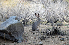
 A jack rabbit below.  They are all over the place, as is mule deer and Gambel's Quail.
 The next day we drove the Jeep down I-10 to US-95, about 25 miles west of Needles, and went north to the Mojave Road.  From Wiki:  
The Mojave Road or Mojave Trail is a historic route and present day four-wheel drive road across what is now the Mojave National Preserve in the Mojave Desert.  A traditional thoroughfare of desert-dwelling Native Americans, the road much later served Spanish missionaries, explorers, and foreign colonizers and settlers from the 18th to 19th centuries, and ran between watering holes across the Mojave Desert between the Colorado River and San Bernardino Mountains in Southern California.
Below, a rest stop as we just finished the climb out of the canyon from US-95 entrance onto the Mojave Road.  It was about 10 miles so far from US95.
Above, the Road looking west and into the National Preserve.  Below, we stopped for lunch near an old coral, in the proximity of the former Fort Paiute.  We looked every where for the ruins/remnants of the Fort, but never found them.  The Preserve map we used to get here indicated this was where it was, but we sure didn't see anything.  Oh well!
On the way back to the MH and some 40 miles across the Preserve via the Mojave Road we snapped a pic of these mule deer.  The Jeep is sure a happy camper as she is just filthy and dusty.  The way she likes to be. Miss Jeepy sure takes us to places where other vehicles can not.  We sure like going off road.

I must add here that we did go over to the Kelso Depot along the Union Pacific RR south of Cima, CA.  Somehow Nancy's camera corrupted the pics she took of the Depot, and they were some neat pics.  :-(  
From Wiki:  The Kelso Depot, Restaurant and Employees Hotel or Kelso Depot, now also the Mojave National Preserve Visitors Center, is located in the Mojave Desert within the National Park Service Mojave National Preserve, on Kelbaker Road in Kelso, California.  

So, we left Mojave and drove to Yuma, via Havasu City.  We are at the Yuma Proving Grounds (Army) Desert Sands FamCamp.   We arrived here on Thursday 2/23 and will be here far a week.  So, till our next blog, so long from the RVing Beach Bums.

Sunday, February 19, 2012

Kings Canyon National Park

 The Visitor's Center is at 7000 plus feet, so it didn't surprise us that there was snow here.  Around 40 degrees and no breeze, so it was pleasant walking around.
 The main attraction here near the visitor center is Grant's Grove, a large grove of giant Sequoias.  And we captured some of them in our pics.  Hope you enjoy them as much as we did snapping them.  They are just breath taking.
 This fallen giant was actually used as a "cabin" for two years by the Gamlin brothers while they were building their real cabin.  Later they used it as a bar, eatery, and the Calvary even used later as a stable for up to 32 horses.
 I could ramble on about these marvelous grand giants of nature.  But the pics say it it all.
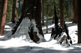
 Lightning got the tree to the left many years ago.  The trees are resistant to fires and insects, as they posses natural chemical makeup to repel all insects, and their bark is so thick, that it protects the inner tree, hence, growth for many centuries.  The trees go through major fires on average every 13 years, so if some of these giants are 1500 years old, that's a lot of heat they've endured.  Man's harvest has been their biggest threat during their lifetimes.
 Above, an infant Sequoia.  They can grow 3 feet each year.
 The grove had quite a few visitors, as it was a gorgeous day to be there, and it was Saturday.  Kings Canyon was quite a drive away however.  From where we were camped, Horse Creek, we drove about 60 miles through back roads and Pinehurst, CA.  The return trip had us going through Fresno, and a stop at one of our favorite eateries, Sweet Tomatoes, and this return trip wound up being about 70 miles.  Gas prices are horrendous here in CA.
 On our way out of the park, we did manage to snap off a few pics of the Sierra Navada peaks.  And below is Hume Lake, a man made lake that was used to power a lumber mill over a hundred years ago.  The lake is now used primarily by the Hume Lake Christian Camp.  We drove through the camp, and it is HUGE!  Up to 200 visitors per week, all year visit camp here.
 Above, one of the slopes for the campers.  Below, the full size hockey rink, and they have a Zamboni for grooming the ice.  And in the summer it's used as basketball courts.
 Below is the snow groomer in action.
 And below is a view up King's Canyon towards the peaks.
 Caught this little guy posing for me.  Below, I caught him "scratching".
So ends our visit to the two NPs here in the Sierra Nevada's.  It was rewarding.  It's Sunday morning, so time to get cleaned up and head to services, and drive on to the Mojave Desert.  So, till the next time, RVing Beach Bums.